Shutdown Roadtrip Part 2

Shutdown Roadtrip Part 2
I continue my drive into the wild, untended parks during the government shutdown of 2018.
As I headed out from Crater Lake, I entered my second day of driving along two lane roads without ever touching an interstate. For somebody from Southern California, where I get on the freeway to go the four miles to drop my son off at school, this freedom from freeways was magical. On top of that, the snow covered fields in Oregon were absolutely beautiful. These couple of days, driving through the very northern reaches of California and southern Oregon were desolate, empty, lonely, and utterly recharging.
Redwoods
As I dropped back into California and towards the coast, the snow on the ground slowly started to dissipate and reveal a magical forest. The entire way through the Pacific Coast Range of mountains it felt like driving through Endor.
I arrived at the Redwoods National Park Visitors Center towards sundown, but didn’t know exactly where I wanted to go. I quickly looked up a park map on my phone while sitting outside the closed visitors center and found a way into the park that looked promising. I drove up to the Lady Bird Johnson Grove just as the sun was setting, and set off to walk the short loop around the grove.
This forest was everything I ever picture when I picture a forest. There was a dense undergrowth of ferns, and redwood trees towering overhead. The only thing missing were small dinosaurs running underfoot. As the skies grew dark, I continued my walk through the forest, taking in its beauty more than photographing it. This was the first time throughout the trip that I wish I was sharing the experience with someone.
I returned to my car and got ready for the night. I was the only one left in the parking lot for the LBJ Grove, so I decided to just eat and sleep right there. I even had cell service, which is rare for national parks.
Once again, I was up before the sun to capture the sunrise. As I drove further into the park, the road rose up to look down on the cloud filled valleys leading to the ocean below. As the sun came over the horizon, its golden rays gently kissed the tops of the clouds as I could see them churning in the breeze.
From there, I took an off-trail stroll through the forest, trying to capture the sun through the trees. I had a specific shot I wanted in my mind, a challenging one looking directly into the sun with enough detail on the backlit trees to make them more than just silhouettes. After some trial and error, I had captured the shot I wanted and headed back to my car.

Patricks Point State Park
While goofing around on the internet after dark in Redwoods, one of my old college professors suggested I visit Patricks Point State Park, just south of Redwood National Park. I had a bit of time to spare before I needed to get down to the Bay Area for sunset, so I decided to stop.
Patricks Point is one of those state parks that would be easy to pass by if you didn’t know it was there. There is just one little sign off of the 101, but it’s a beautiful park right on the Pacific Ocean.
Since it’s a state park, and not a national park, it was operating completely normally. This was the one and only time during the entire trip when I had to pay to enter a park. (I have an annual pass to the National Parks anyways, so I wouldn’t have had to pay anyways, but you get the idea.)
Since Patricks Point hadn’t been on my itinerary initially, I had no idea what there was to see or do here, and I didn’t have much time. I grabbed the park map from the ranger at the entry gate and took a quick look. Patricks Point isn’t that large, so I picked the furthest spot I could find, drove to the end of the road, and started hiking out to sea. It was still early enough in the morning that the light was good and the shadows were long. I rushed out to see if I could capture anything worthwhile.
While I was out on these rocky outcroppings that jutted from the sea was the coldest I was throughout the entire trip. The air was moist and the wind whipped around me. My car told me it was in the upper 30s, nearly 20 degrees warmer that I had become accustomed to over the preceding days. I looked at the temperature and thought I didn’t need four layers, top and bottom, to stay warm. Boy, was I wrong.
I hurried back to the car after snapping a few photos. I was cold, and I didn’t want to dally too long and risk missing the light at the Golden Gate Bridge.

Bay Area
This entire trip was focused on nature, but it was a very long drive from Redwoods to Pinnacles, so I decided to make a stop in the Bay Area to break up the drive. There are plenty of things to take pictures of around San Francisco, and the most iconic is the Golden Gate Bridge.
I had a very specific picture in mind that I wanted to capture. I wanted to be on the northeast side of the bridge, with the bridge on the right side of the image and the city skyline extending to the left. Looking at a map, there seemed to be a place in Fort Baker where I could get the picture I wanted. I pulled off PCH at the last exit before heading over the bridge and found my way down a number of narrow, winding roads to get near where I thought I wanted to be.
After parking, I noticed that the Fort Baker Fishing Pier hadn’t shown up on my map, but was exactly where I wanted to be. It was again cold and windy, but I had learned my lesson at Patricks Point and this time I brought all of the jackets.
I set up at the end of the pier and tried to line up the shot I wanted. Unfortunately, the only way to get that picture would have been to do a panorama and have a big section of boring hillside right in the middle of the image. The real world just didn’t lay out like it did in my mind. But I was in a great position to get a picture of the Golden Gate Bridge at sunset, so I set it to wait for the light.
I was the last person on the pier, but I had gotten a picture I was happy with. It was New Years Eve, I wasn’t quite sure where I was staying the night, it was time to head out and figure that out.
The next day a friend was having a New Years Day open house in Morgan Hill, so I decided to head that direction so I had a shorter drive in the morning. I drove over the Golden Gate Bridge for the first time in my life, through San Francisco, and down to San Jose where I found a cheap motel for the night. I needed a shower before the party the next day.
For once, the sun arrived upon the day before I did. In fact, I barely made my late checkout time. After quickly getting ready, I headed towards my friend’s New Years Day open house and spent a wonderful few hours with friends I’ve known for more than two decades. It was great catching up, but eventually I had to head out so I could catch the sunset at my next destination.
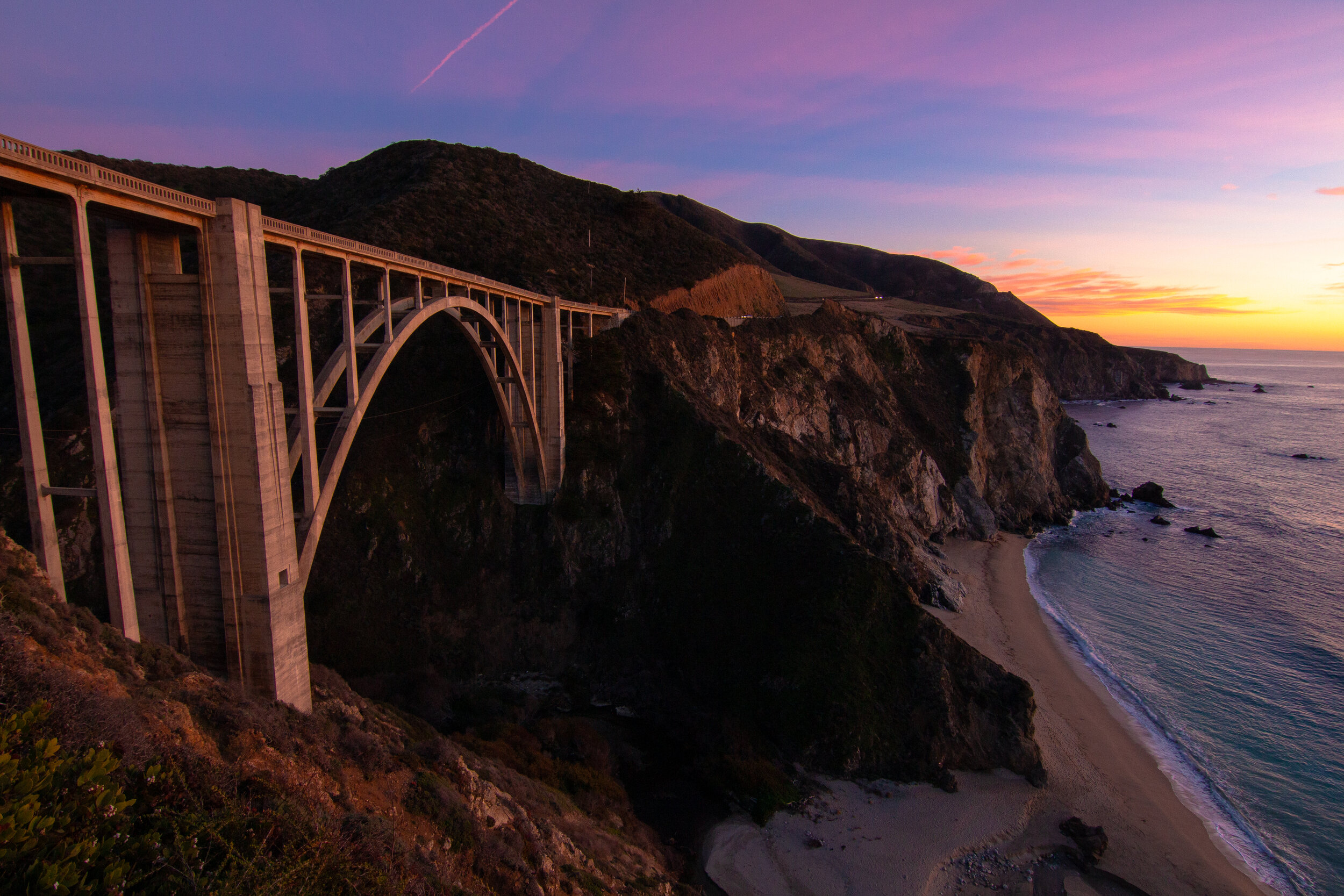
Bixby Canyon Bridge
I had three options for my last sunset on the road. I could head directly to Pinnacles National Park and have both a sunset and sunrise there, I could head to McWay Falls which I often see on Instagram with the Milky Way across the sky, or I could head to the Bixby Canyon Bridge which is the second most photographed bridge in California after the Golden Gate Bridge. Since it was the wrong time of year for the Milky Way to be visible, and I’d be at Pinnacles in the morning, and I love Death Cab for Cutie, I decided to go to the Bixby Canyon Bridge.
Because Bixby Canyon is such a popular photography spot, I was not the only one there with a camera trying to capture the bridge at sunset. However, all but one other person stayed up on the shoulder of the road and took photos from there. I descended down the dusty gravel ridge a bit and found a small clearing with just one other photographer where we were able to take photos looking slightly up at the bridge. The other photographer was waiting to take a night shot, while I was just waiting through sunset to take photos throughout as the light changed.
I captured the shot I wanted for this trip, but this is a place I want to come back to during the summer months to capture Bixby Canyon Bridge with the Milky Way in the background.

Pinnacles
Once the sun had set at the Bixby Canyon Bridge, I headed back up through Monterey and inland to SR-25 into Pinnacles. Once again, I was on a wonderful two lane road in the middle of nowhere. By this time it was late at night, and I was the only one tearing through the blackness of a moonless night.
From the places I had been throughout this trip, Pinnacles seemed to be the least photogenic. I arrived in the park at midnight and quickly got to sleep. I’d have one shot to get something decent in the camera, and I didn’t have a good idea of where to go to make that happen.
Up before dawn, I raced down the nearest trail I could find, but my heart wasn’t in it. I wanted to get home. As dawn approached, I took a few photos of the rock formations, but I started to head back to the car before the sun crested the horizon.
As I drove back towards civilization, I was once again treated to an empty ribbon of tarmac threaded around hillsides and through grass covered valleys. Cows stood munching on their breakfast or walking single-file through the fields. The rising sun was before me, in my eyes, blinding me around corners that I took far faster than was safe. After a week on the road, I was headed home and couldn’t wait to get there.
